Trails for People and Wildlife
Supporting nature and recreation the New Hampshire way
Hiking, mountain biking, bird watching, and horseback riding are just some of the ways we get outside to enjoy nature and relax. However, even these seemingly low-key activities can have a negative impact on wildlife by reducing their abundance, reproductive success, or even survival. A new mapping tool and guide called Trails for People and Wildlife aims to encourage people to get outside and enjoy nature while allowing wildlife to thrive. It was funded by the US Fish and Wildlife Service and produced by the NH Fish and Game Department and Great Bay National Estuarine Research Reserve.
Intended for landowners, conservation groups, and natural resource professionals, the objective of Trails for People and Wildlife is to help facilitate the placement of thoughtfully located networks of well-maintained trails. It tries to balance having wildlife species there for all of us to enjoy for years to come while providing trail builders with the resources needed to achieve their public access goals. Often a trail is used for multiple types of activity and consideration of wildlife is just one piece of the puzzle. Whatever a trail’s primary purpose, the tips and statewide mapping tool described in this guide can be used to ensure it is laid out in the most wildlife-friendly way.
When looking across New Hampshire’s landscape, there are some key principles that can easily be followed that will reduce trail use impacts to wildlife. For example, avoiding wet areas or slopes protects rare wildlife and also minimizes the need for trail maintenance. Each principle was mapped throughout New Hampshire using a Geographic Information System (GIS) and the multiple layers integrated to show where it is best to locate trails. A draft model was reviewed by both trail and wildlife experts including staff from the National Parks Service, NH Trails Bureau, NH Audubon, Upper Valley Trails Alliance, The Nature Conservancy and US Forest Service before a final product was produced.
The University of New Hampshire’s online mapping service “GRANITView" provides free access to GIS tools through the internet. The Trails for People and Wildlife location tool is available as a clickable layer within this easy-to-use web application. GRANITView allows us to create customized maps that can be zoomed to a specific area of interest, for example a parcel of conservation land, town forest, or schoolyard. Users can search for data and display it in multiple ways. Customized maps can be printed and shared with others. For GIS users, the Trails for People and Wildlife coverage is available for download in raster format from NH GRANIT, the state’s GIS clearinghouse.
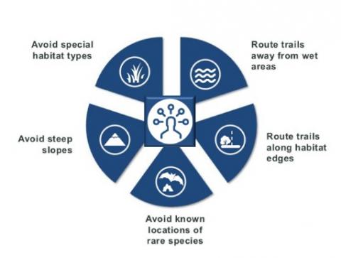
Key principles for minimizing trail impacts to wildlife.
The trail location tool is displayed as a “heat map.” Simply put, the warmer the color, the higher impact on wildlife if a trail passes through, so avoiding red areas is particularly important. When planning a trail system, the goal is to “follow the blue” as much as possible to find the best route that minimizes impacts to wildlife while getting people outside to explore and interact with nature.

The Trails for People and Wildlife handbook describes how to implement the mapping tool on any property you are interested in and overviews other aspects of smart trail planning such as deciding what types of use should be allowed. It also looks at trail planning from a community perspective. Some properties lend themselves to being highly publicized “ambassador” properties while others with particularly sensitive natural resources will ideally be left as undisturbed as possible. Although only recently released, the Trails for People and Wildlife location tool has been received well and is starting to, quite literally, get on the ground. For example, based on this tool trails were created, closed or rerouted on the Southeast Land Trust’s Stonehouse Forest, a 1,535-acre property in Barrington. Additionally, the Deerfield Conservation Commission has developed language for use in new conservation easements that says “trails may be located, cleared, constructed, and maintained, provided these trails are consistent with the Purposes of this Easement and NH Fish and Game methodology for planning and Managing “Trails for People and Wildlife” or other equivalent science based methodology”.
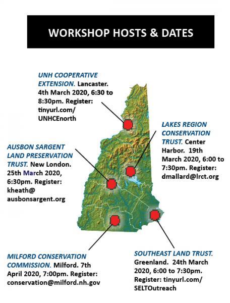
The handbook can be downloaded and used by both private landowners and professionals to select locations for new trails and to determine where it is best to maintain, reroute, or decommission existing trails to optimize human experience and minimize wildlife impact. Visit Trails for People and Wildlife to read and print the entire guide. There are five workshops planned for Spring 2020 across the state. See the map below for workshop locations, dates, and registration information.